


With COP 26 having come to a close, 197 countries have agreed to new rules in the Glasgow Climate Pact in order to limit greenhouse gas emissions. Although the agreement covers several measures such as coal power, carbon markets, and funding for developing countries the world is still on track for a 2.5-2.7°C warming by the end of the century, compared to pre-industrial times. This leaves the world far from the ideal 1.5°C goal previously set by the Paris climate accord. It is important that countries keep to their commitments over the next few years, but just how important? Our data scientists have explored how climate change, in a business-as-usual scenario, will affect weather in the UK.
Working with large data
The Met Office runs a large-scale climate modelling project called the UK Climate Projections (UKCP). Their climate models simulate how atmosphere behaves over time, factoring in the change in greenhouse gas concentration. For the visualisations below, we used the 2018 projections based on a warming scenario called “RCP8.5”. This is considered a ‘business as usual’ scenario, reflecting what will happen without major efforts to cut greenhouse gas emissions. Under an RCP8.5 scenario, global average temperatures are expected to rise by 4.3°C by 2100, compared to the pre-industrial period (1850-1900).
We automated the downloading of UKCP land convection-permitting model projections using CEDA’s FTP (File Transfer Protocol). We focused on daily projections for total precipitation (“pr”) and maximum temperature (“tasmax”) downscaled to a high resolutions (2.2km) but presented on a 5 km grid basis of the UK. At its largest, this amounts to almost 1 billion observations for each variable of interest, about 3GB of data for each variable.
We have used R to convert the data into a tidy format, match the data with UK postcodes, match the data with the UK national grid and plot the data.
How will the UK's weather change?
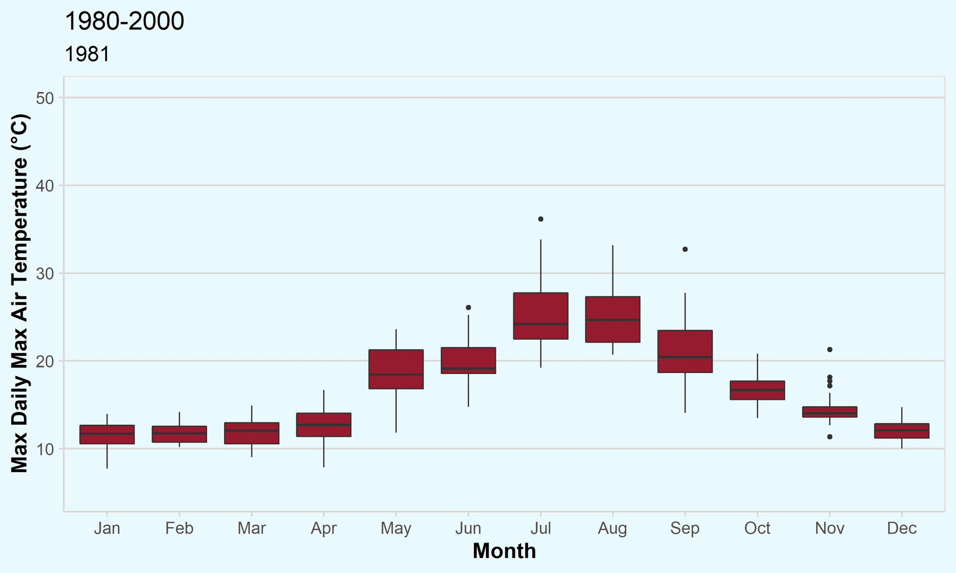
Figure 1 - Max daily temperatures across the UK, 1980-2000, 2020-2040, 2060-2080
Note that we omit 1980, 2000, and 2020 from the chart as these years only have data for December. Also note that 2080 does not have any data for December.
This chart presents the monthly variation in maximum air temperature across the UK over the periods 1980-2000, 2020-2040, and 2040-2060. For this, we calculated the highest maximum air temperature in the UK on every day within these periods. The distribution of these days is presented in the boxplot for each month.
We can observe an increasing temperature in the UK, particularly in the summer months, as time goes on. In 2080, the mean max air temperature in the UK in August is projected to be around 30 °C, a 5 °C increase compared to the 2021 figure. Winter temperatures are also projected to increase significantly over the coming years.
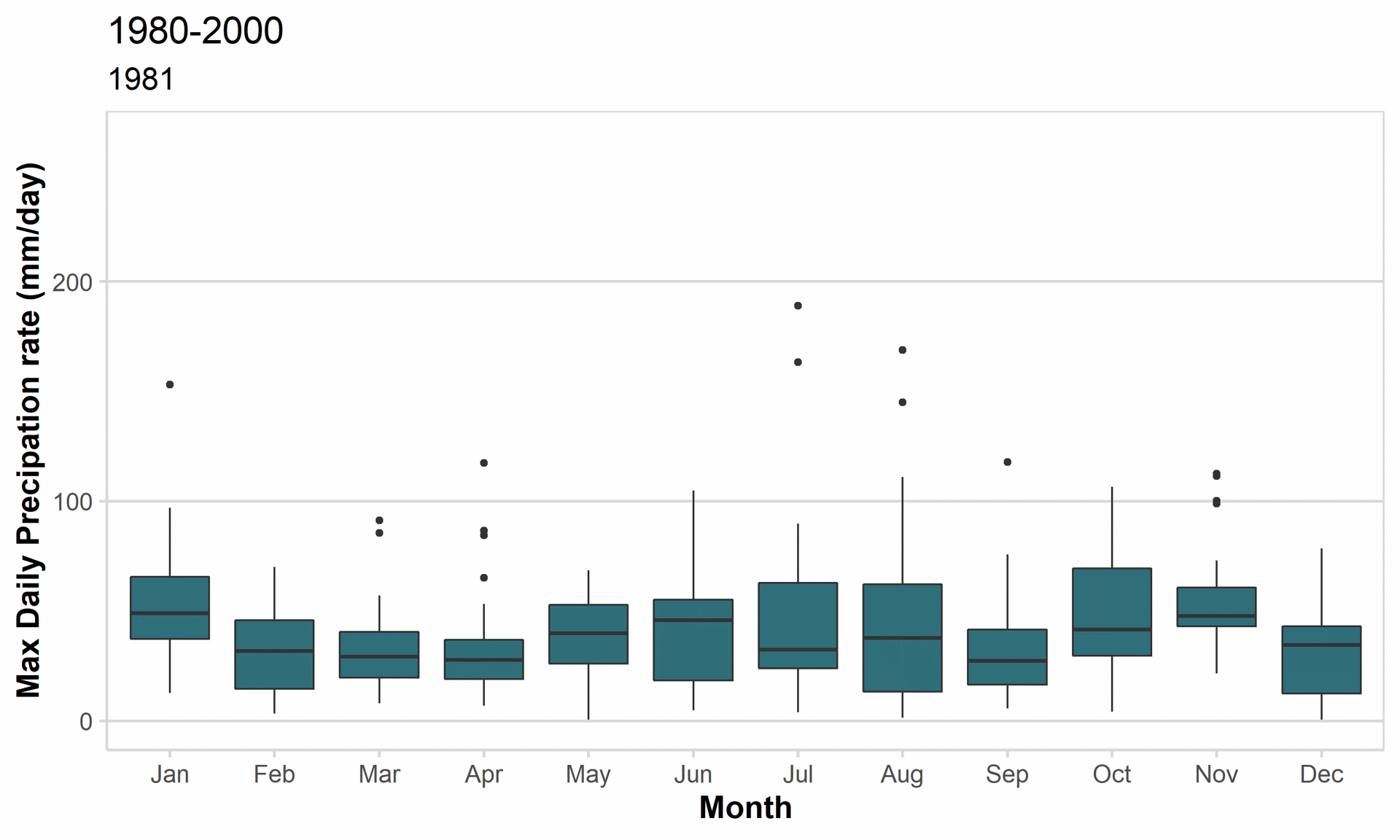
Figure 2 - Max daily precipitation rate across the UK, 1980-2000, 2020-2040, 2060-2080
Note that we omit 1980, 2000, and 2020 from the chart as these years only have data for December. Also note that 2080 does not have any data for December.
This charts presents the monthly variation in maximum precipitation rate across the UK over the periods 1980-2000, 2020-2040, and 2040-2060. For this, we calculated the highest precipitation rate in the UK on every day within these periods. The distribution of these days is presented in the boxplot for each month.
There is no significant change in precipitation over time. However, we do see an increase in outliers (both in number and magnitude) over time. This suggests that there will be an increase in sporadic heavily rainy days. Moreover, this chart hides spatial variation in precipitation rates. Regionally, precipitation is projected to change over time. This is what the precipitation spatial map below shows.
How will climate change affect local parts of the UK?
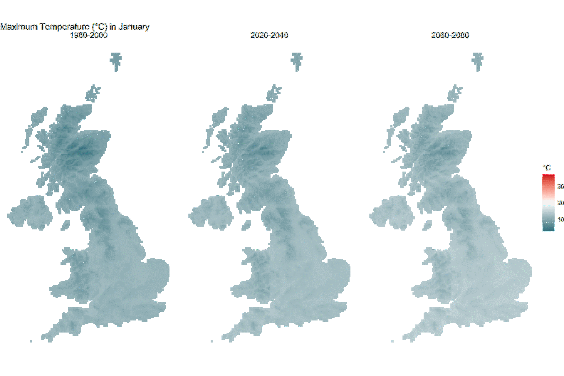
Figure 3 - Animated chart showing monthly spatial variation in max temperature across the UK, 1980-2000, 2020-2040, 2060-2080
This chart presents the spatial variation in maximum air temperature in the UK for the periods 1980-2000, 2020-2040, and 2040-2060. For this, we calculated the highest maximum temperature in a month in every 20-year period in each 5km grid. The visualisation shows all parts of the UK get hotter over time, especially in the summer months. The South-East of the UK will experience the hottest days.
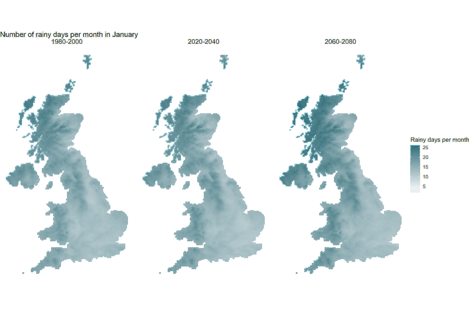
Figure 4 - Animated chart showing monthly spatial variation in rainy days across the UK, 1980-2000, 2020-2040, 2060-2080
This chart presents the spatial variation in rainy days per month in the UK for the periods 1980-2000, 2020-2040, and 2040-2060. For this, we calculated the number of rainy days in a month in every 20-year period in each 5km grid. We define a rainy day as a day with over 1mm of precipitation.
The trend in precipitation varies regionally across the UK. Over time, the North-West of the UK (Northern Scotland) will experience more rainy days (most prominently in the winter), whereas the South-East and parts of Wales will experience fewer ones.
How will climate change affect weather in my neighbourhood?
In order to visualise the local effects of climate change in the UK, we have matched postcode data (from the ONS) with the projection data. The interactive portal below shows how the maximum air temperature and monthly number of rainy days is predicted to change in each postcode across the UK. Use the text box to search up your postcode! Please note that as the projection data is on a 5km grid, there are multiple postcodes per grid, that have the same charts.
Moving beyond the numbers
As the visualisations show, the effects of a business-as-usual approach to climate change are significant and far-reaching, both locally and across the UK. It is important that countries keep to (or even do better than) the commitments made in Glasgow over the past 2 weeks. If not, the changes to the weather will be drastic and perhaps unliveable. And although this piece has focused on the UK, we must not forget that our actions also affect all other countries in the world.